Hokkaido Water Temperature and Wetsuit Guide: Seasonal Table from Japan Meteorological Agency Data
Contents
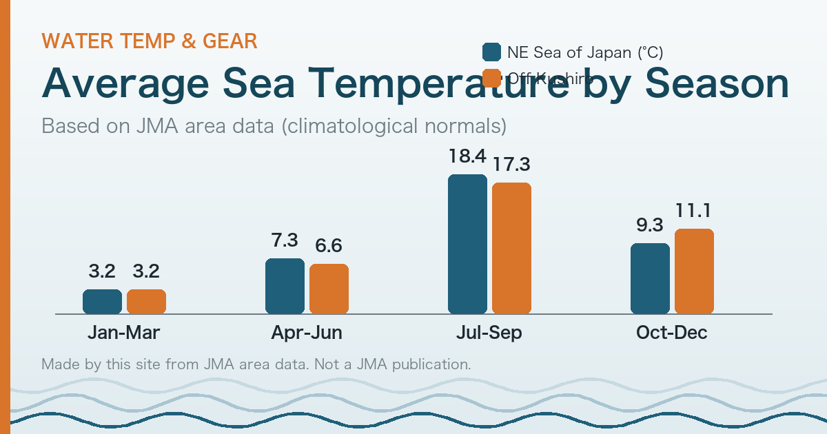
In short: according to the Japan Meteorological Agency (JMA) climatological averages, sea surface temperature around Hokkaido is about 3°C on average from January to March and about 17-18°C from July to September. That is a gap of roughly 15°C between winter and summer. These figures are averages over wide sea areas that include offshore water, so they do not match the water at the shoreline. Use the table to understand the size of the seasonal swing before you choose gear, not to decide whether to go in.
How cold is the sea around Hokkaido?
JMA divides the seas around Japan into areas and publishes area-averaged sea surface temperature normals (averages of observation-based analyses over 30 years, 1991-2020). Here are two areas that touch Hokkaido, by season.
| Season (JMA’s definition) | Northeastern Sea of Japan | Off Kushiro |
|---|---|---|
| Jan-Mar | 3.19°C | 3.22°C |
| Apr-Jun | 7.26°C | 6.57°C |
| Jul-Sep | 18.39°C | 17.30°C |
| Oct-Dec | 9.31°C | 11.14°C |
| Annual | 9.54°C | 9.56°C |
Source: created by this site from JMA’s area data on “Long-term trend of sea surface temperature (around Japan)” (in Japanese). Normals are 1991-2020 averages. Checked on 2026-10-18.
This table was made by this site. It is not a JMA publication.
Three cautions when you read this table:
- JMA’s seasons are not the usual weather seasons. For sea surface temperature, JMA uses winter = January-March, spring = April-June, summer = July-September, autumn = October-December (source: explanatory text on the same JMA page). December falls in the autumn row.
- Area averages include open water. Shallow beaches, river mouths, and the days right after rough weather can differ from these numbers.
- The area names follow JMA’s sea-area map. “Northeastern Sea of Japan” is on the Sea of Japan side; “Off Kushiro” is an example of an eastern Pacific-side area. A beach on the southern Pacific coast of Hokkaido is not necessarily the same temperature (check JMA’s area map for the boundaries).
How do I think about gear from water temperature?
There is no official standard for gear by water temperature. The table below lists rules of thumb from articles by media and a retailer, with sources. All of them are commercial articles, not public standards. Feel varies by brand, shop, and body, so please ask a specialist shop before you buy.
| Period | What the sources say | Source |
|---|---|---|
| Midwinter (late Dec - mid Feb) | A semi-dry suit is essential; a thickness of “5x3 mm to 5x4 mm” is a guide. On the colder Sea of Japan side, a fleece-lined type is an option. Boots of about 3 mm and gloves of 2-5 mm are common | Jackery, “Winter surfing” (updated 2026-01-22) (Japanese). Jackery sells portable power stations; the article is on its own site and includes promotion |
| Winter, Pacific side around Tomakomai and Atsuma | Full gear including a head cap is needed; a drysuit is recommended | Namiaru Media, point guide (Tomakomai area) (Japanese; updated 2025-08-15) |
| June onward (as stated in the English guide) | The English guide says a 3/2 mm or 4/3 mm should do on the Pacific side in summer, and for Uchiura Bay (Funka Bay) suggests 3/2 mm in June and 5/4 mm with hood and full gear in January | The Surf Atlas |
| Summer (August) | The water warms up, and people used to it may wear just trunks (water temperature varies by year and beach; ask a shop, including about protection from scrapes and sunburn). Air temperature can reach 30°C | Namiaru Media, point guide (Tomakomai area) |
| Spring and autumn | The table above puts water between the winter and summer figures. Please ask a specialist shop | No public source found (as of 2026-10-18) |
The English guide The Surf Atlas describes winter water as “Baltic”. Sources describe gear in different ways, so please read the table above as one rule of thumb among several.
How should I use the numbers?
Use them to grasp the size of the seasonal change before choosing gear. Do not use them to decide whether to enter the water. For conditions on the day, ask a local shop or the managing body.
Some English sources give higher figures for Hokkaido water temperature, and the numbers differ from source to source. This site starts from JMA’s normals, which are based on analyses of observations, and names every source.
What this article does not do
- It does not forecast today’s or tomorrow’s water temperature or waves. The table is a summary of 30-year averages, not a forecast. (Why: see About this site.)
- It gives no medical explanation. For cold-related health questions, please consult public agencies or professionals.
- It does not promise safety. Good gear does not remove the risks of cold water. For water safety, see the safety article, which is available in Japanese only for now: 北の海の安全.
This site is not affiliated with any shop, school, brand, or public body mentioned above.
Sources
- Japan Meteorological Agency, long-term trend of sea surface temperature (around Japan) and area data (normals: 1991-2020). Checked 2026-10-18
- Jackery, “Winter surfing” (updated 2026-01-22); Namiaru Media, point guide for the Tomakomai area (updated 2025-08-15); The Surf Atlas (2024-10-28, updated 12-11). Checked 2026-10-18